 EOMeasy
End-of-month volumes, measured and signed off. Without a mine-design suite.
EOMeasy runs on the Windows machine you already have and turns your survey into a month-end you can sign off: every stage batched into one run, a branded report, and a universal CSV. Feed it point clouds straight from a drone, GPS or scanner, or surfaces from your existing package, with no mine-design software licence in the loop. The volumes come out the same as Vulcan and PointStudio, proven to 0.005%, so they hold up when the report reaches management.
Run your next month-end free · 30 days · no card · on your machine
case study demo
Your package already calculates the volumes. This is the part it makes you do by hand.
The volumes aren't the hard part; your package computes cut and fill fine, and if you don't run one, EOMeasy grids your point clouds itself. The grind is everything after: opening each stage, keying numbers into the same spreadsheet, formatting the report the manager signs, and proving it reconciles with the numbers your current process already produces. EOMeasy is that layer, built by a mine surveyor who ran that grind by hand for years.
Every stage in one run
From a config you set once and clone forward each month, not one stage at a time, keyed by hand.
For the manager, and for everything downstream
A branded PDF for sign-off, and a stable CSV schema the spreadsheets downstream can depend on.
The independent check, done properly
Figures you can trace straight to Vulcan, PointStudio, or your chosen software, arrived at by a second calculation that shares no code with it. EOMeasy is its own implementation of the same well-understood approach, with exact partial-cell weighting where a cell straddles your boundary. Warnings on degraded inputs, never a silent wrong number.
Three steps, all on your machine.
Bring your surveys in
Export start/end surfaces from Vulcan, PointStudio or your chosen software, or LandXML from a civil package like Civil 3D or 12d, or drop in point clouds straight from a drone, GPS or scanner. The LAS, LAZ and PLY exports from DJI Terra, Pix4D and Agisoft Metashape work as-is, no special importer, no CAD package needed.
Run the month
Point each stage at its surfaces and press run. EOMeasy samples with exact boundary weighting, applies your material / swell / density settings, and computes average RL.
Send the report
Out comes a branded PDF for sign-off and a universal CSV that reconciles to your package, ready for the manager and whatever spreadsheet lives downstream.
The report that goes to management, and the proof it reconciles.
Every run produces a branded, multi-page PDF: a cover with the month's net movement, a page per stage with the plan view and the cut / fill / BCM / tonnes tables, and a summary that ties back to your package. This is a real one: open it, or download the sample.
Two ways to licence a site.
Try it free for 30 days first, no credit card. When you're ready to keep it, pick a plan.
14-day money-back guarantee on either plan: run a real month-end on it, and if it doesn't reconcile we'll refund you.
Approx US$1,750 · billed in AUD.
- Unlimited runs, every stage
- White-label reports: your logo and company name replace EOMeasy's on every page
- Universal CSV, updates and email support
- Runs on up to three computers at your site or office; keeps working offline for 30 days
A surveyor loses a day or two to this every month-end. The licence pays for itself the first month, and gives the rest of the year back.
Approx US$100 / month · billed in AUD.
- Unlimited runs, every stage
- Reports carry EOMeasy branding (not white-label)
- Universal CSV, updates and email support
- Runs on one computer; keeps working offline for 30 days
Want your own logo and company name on the cover? That is the annual site licence.
The questions procurement asks.
We already calculate volumes in our current software. Why pay for this as well?
You should keep calculating them there. EOMeasy does not replace it, and if your procedure asks for the figure to be checked independently, it should not. What it replaces is the day or two after the volumes are done: opening each stage one at a time, keying numbers into a spreadsheet, rebuilding the report, and checking the totals still tie out. Your package computes cut and fill in seconds. It is everything downstream of that which eats month-end.
EOMeasy batches every pit, stage and bench in one run, produces the report your manager actually reads with your logo on the cover, and exports a CSV that ties straight back to your package's own figures. It also reaches those volumes independently. It is a separate implementation, written from scratch and sharing no code, no library and no settings with your package, so a bug or a stray setting in one is not mirrored in the other. On a five-volume public reconciliation they agreed to within 0.005% on every production volume. That is not asking you to trust a different number. It is two independent calculations producing the same one.
If your month-end takes an hour and nobody asks you to reformat the report, you do not need this. If it takes a day or two, that is twelve to twenty-four days a year.
Our procedure requires an independent check of the volumes. Does this satisfy it?
That is your call and site procedures differ, so we will not tell you it does. What we can tell you is what EOMeasy is: an entirely separate implementation of the volume calculation. It shares no code, no library and no settings with Vulcan, PointStudio or 12d. It drapes both surfaces on a fine regular grid, differences them and integrates by cell area, clipping cells that straddle your boundary to their exact intersection and sampling at the clipped centroid. Run the month in one and check it in the other and the two results are arrived at independently, rather than by the same engine run twice. That is the point of a check.
Be clear about what it cannot catch, because no two-method check can. Both calculations start from the surfaces you give them. If that is the wrong surface, or the survey behind it is misregistered, or the two surfaces sit on different grids or height datums, the two will agree with each other and both be wrong. Agreement tells you the arithmetic is sound. It does not tell you the inputs were right, and that part stays with the surveyor exactly as it does today.
It does not replace the second surveyor. Where your procedure says another person checks the figure, this means that person can do it without a CAD licence of their own, which is usually the reason the check gets deferred or waved through. On a five-volume public reconciliation the two agreed to within 0.005% on every production volume, so the check tends to be a formality rather than an argument.
Does any of our survey data leave the machine?
No. All computation and every surface stay on your Windows machine. The only things EOMeasy sends over the network are a licence check and an update check at startup, and neither includes survey data. There is no cloud upload, by design.
Do I need Vulcan, PointStudio or any CAD package?
No. If you run a package, EOMeasy reads the neutral surfaces it exports (DXF, OBJ, STL and LandXML), so you're never locked to one vendor's format. And if you don't run one at all, it reads point clouds directly (LAS, LAZ, PLY, XYZ and CSV) from a drone, GPS or scanner, including the standard exports from DJI Terra, Pix4D and Agisoft Metashape, and grids them into the same report and reconciliation, no expensive subscription required.
You don't buy a CAD package to make surfaces for it. If you fly a drone, you already made the cloud when you processed the flight. The one step worth doing is trimming that cloud to the area that moved: see Trim a drone point cloud to the area of interest.
Does it work with my drone software (DJI Terra, Pix4D, Metashape)?
Yes, directly. Those packages export point clouds as LAS, LAZ or PLY, which EOMeasy reads natively. Export the point cloud, point EOMeasy at it, and it grids it to a surface and reconciles the volumes the same way it does a Vulcan or PointStudio surface. There is no separate importer to install and no format conversion step. For the exact steps to trim the cloud to your area of interest first, in each of those three packages, see Trim a drone point cloud to the area of interest.
We already measure stockpiles with a drone survey platform (like Propeller Aero). Where does this fit?
Alongside it, not instead of it. A drone platform is built to capture the surface: fly the site, process it, and read a volume off the model, typically very close to a ground survey. EOMeasy does a different job. It reconciles that volume back to the way Vulcan and PointStudio compute it, to within 0.005% on a five-volume public reconciliation, so the figure that goes on a royalty return or a payment claim is provable, not just fast. A measured volume is only ever as good as the base surface it sits on, which is where that small remaining variance lives, and that is exactly what the reconciliation checks.
To do that, EOMeasy needs the surface out of your platform. If you process your own flights in DJI Terra, Pix4D or Metashape, it reads the point cloud (LAS, LAZ, PLY) directly. Cloud platforms are more closed, so from those you would export a surface in a neutral format such as DXF, OBJ or LandXML where the platform allows it, which EOMeasy reads just the same. Either way the work runs on the machine you already have and none of it is uploaded, so the reconciliation adds no cloud service or ongoing processing fees, just the licence.
If you process your own flights, trimming the cloud to the area of interest before export is the whole workflow, no CAD in the middle.
What do we need to run it?
A single Windows PC. The one your survey package already runs on is ideal, but any modern Windows machine works. It's one installer, no server and no IT rollout, and nothing else needs to be open: EOMeasy reads the surfaces or point clouds you point it at.
Can it handle all our pits, stages and benches in one run?
Yes. A run batches every volume you've configured in a single pass, each keeping its own boundary, surfaces, material and grid resolution. You set a site up once and clone it forward each month, rather than opening and keying one stage at a time.
What if it doesn't work out?
Both plans carry a 14-day money-back guarantee. Buy it, run a real month-end on your own surfaces, and if it doesn't reconcile against your package or doesn't suit how you work, email us within 14 days and we'll refund you in full. No forms and no arguing. Lite is month to month as well, so you can simply cancel and it stops at the end of the month. Most people take the free 30-day trial first, which means by the time you buy you've already seen it run on your own data.
How does licensing work?
Per site, per year, covering up to three computers at the site. The site is the operation whose volumes you reconcile, so a second pit up the road is its own licence. Firms that review or certify volumes produced by others licence per office instead: same price, three computers, unlimited projects. Each activation is tied to the computer you install it on, and keeps working offline for 30 days, so a dropped connection at month-end never stops a run. Need it on more than three computers? That's a quick conversation, not a hard block. Prefer to start small? The monthly Lite plan runs on one computer with the same engine, month to month, with EOMeasy branding on the report (not white-label). Managing your key, seats and billing is covered in Your account, licence and billing.
Will the volumes match what I get from PointStudio, Vulcan, or my package?
Yes, and closely. EOMeasy computes volumes the way your package does: it drapes your start and end surfaces onto a fine regular grid across each stage boundary, takes the height difference at every cell, and integrates cut and fill by cell area. Cells that straddle the boundary aren't rounded in or out: each is clipped to its exact intersection and sampled at the clipped centroid, so the boundary is honoured precisely, not approximated. For point clouds, it triangulates them to a surface the way Vulcan and PointStudio do, then applies the same exact boundary weighting. The approach is the same one your package uses, which is why the figures agree. The implementation is ours from end to end and shares no code with it, which is why the agreement is worth something as a check. In validation against native package figures, across a five-volume reconciliation on public and owned surfaces, results matched to within 0.005% of Vulcan and PointStudio on every production volume. The tables and CSV are the audit-grade record, built to tie straight back to your package's own cut and fill, and any degraded input (an open boundary, partial coverage, a wall or overhang) raises a warning rather than a silently wrong number. Two things it cannot check for you: whether the surface you pointed it at is the one you meant, and whether the survey behind it is registered correctly. Those stay yours, exactly as they would be if you ran the volumes in your own package, so check the figures against your site records before they go into a payment claim. One related check, mostly for drone data, is worth doing once: both surfaces must sit on the same coordinate grid and height datum, because EOMeasy does not reproject. See Coordinate grid and height.
I can't see the surfaces or check the triangulation like I do in my package. How do I trust it?
Two ways, and neither asks you to trust a black box. When you feed EOMeasy a surface out of your package, it uses that triangulation exactly as you exported it. It does not rebuild or re-triangulate it, so the mesh the volume sits on is the one you already checked and signed off in Vulcan, PointStudio or 12d. When you feed it a point cloud, it triangulates the way those packages do, trims the long boundary-edge triangles that are the usual culprit in an auto-built surface, and raises a warning on a wall, an overhang or partial coverage instead of draping through it silently.
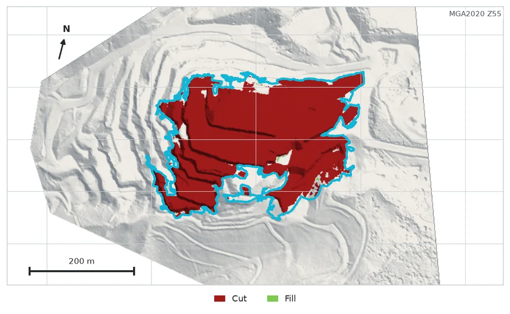
The volume is not read off the triangles anyway. EOMeasy grids the two surfaces and integrates cut and fill by cell area, so a single awkward triangle cannot swing the number the way it can in a triangle-by-triangle takeoff. And every volume in the report carries a plan-view render, cut in red and fill in green over the ground, so you can see on your own job where the movement is and that it sits inside your boundary.
What EOMeasy is not is a 3D surface editor. If you want to inspect or clean a surface triangle by triangle, that stays in your package, and EOMeasy honours whatever surface you export from it.
How are BCM and tonnes worked out?
From the measured loose volume, using the swell and density factors you enter, both opt-in and off by default, so you only see them when you ask. Survey-adjustment figures are carried through as entered metadata, never computed or invented.
Will this tie into our existing process?
Yes. Alongside the branded PDF, every run exports a universal CSV with a stable schema, designed to map straight into the spreadsheets your reporting already runs on, so nothing downstream has to change. There's also a free Excel and Google Sheets workbook that builds the whole month from that CSV: see the month-end workbook.
Is the installer signed?
Yes. The application, the installer and the uninstaller are all signed with an Azure Artifact Signing certificate under Microsoft Organization Public Trust. The publisher on the prompt is our registered company name, "A.C.N. 640 377 457 Pty Ltd", trading as EGB Digital. Your IT team can confirm it in the file's Properties, under the Digital Signatures tab. Windows SmartScreen may still show a notice on a newly published app until download reputation builds: click More info, check the publisher, then Run anyway.
Your data never travels.
No cloud
Every calculation runs on your machine. There is no server that sees your surfaces.
No data upload
The only network calls are a licence check and a startup update check, and neither carries survey data. Your survey data never leaves the site.
No lock-in
Neutral formats in, a stable CSV out. Your data stays yours, in formats everything else can read.
Start your free trial
30 days · no credit card · runs entirely on your machine. Nothing is uploaded.
Already licensed? Download the installer.
Trouble installing? Email hello@eomeasy.com.
Want a walkthrough first?
Prefer to see it run before you commit? Email us and you'll get a proper walkthrough from someone who knows the workflow, not a ticket queue.
Email hello@eomeasy.com